CIGA Catalogue

This catalogue serves to illustrate the products published by C.I.G.A., an entity of the Italian Air Force and the State Cartographic Organisation as stipulated by Law no. 68 of 1960.
 
Each product is illustrated with a sample image, a connection diagram (where applicable), and a brief description thereof.
 
The price list shows the maximum prices applicable by “Authorised Retailers” and beside each product is an alphanumeric code representing the price category.
 
Please note that requests for the supply of the aforementioned products received by this Centre will in all cases be processed subject to institutional commitments. The products can be supplied in the manner described below. 
Product Catalogue

Traditional Cartography - Hardcopy Cartography

Product
Product

Sheet

Sheet

Current edition
Current edition
Year
Year
1501 JOG-AIR
Block 1
Block 1
NL 32-06
NL 33-04
GB 32-09
NL 33-07
NL 32-12
NL 33-10
12 ciga
12 ciga
12 ciga
12 ciga
12 ciga
12 ciga
2022
2022
2022
2022
2022
2022
1501 JOG-AIR
Block 2
Block 2
NL 32-05
NL 32-07
NL 32-08
NL 32-10
NL 32-11
NK 32-02
13 CIGA
13 CIGA
13 CIGA
13 CIGA
13 CIGA
13 CIGA
2024
2024
2024
2024
2024
2024
1501 JOG-AIR
Block 3
Block 3
NK 32-03
NK 33-01
NK 32-06
NK 33-04
NK 33-05
NK 33-07
14 CIGA
14 CIGA
14 CIGA
14 CIGA
14 CIGA
14 CIGA
2025
2025
2025
2025
2025
2025
1501 JOG-AIR
Blocco 4
NK 33-08
NK 33-09
NK 33-10
NK 33-11
NK 33-12
NK 33-10
NJ 34–01
12 ciga
12 ciga
12 ciga
12 ciga
12 ciga
12 ciga
12 ciga
2022
2022
2022
2022
2022
2022
2022
1501 JOG-AIR
Block 5
Block 5
NJ 33-03
NJ 33-04
NJ 33-06
NJ 33-07
NJ 33-08
NJ 33-10
NJ 33-11
13 CIGA
13 CIGA
13 CIGA
13 CIGA
13 CIGA
13 CIGA
13 CIGA
2024
2024
2024
2024
2024
2024
2024
1501 JOG-AIR
Block 6
Block 6
NK 32-11
NJ 32-02
NJ 32-05
NJ 33-05
NJ 33-09
NJ 33-13
NJ 33-14
13 CIGA
13 CIGA
13 CIGA
13 CIGA
13 CIGA
13 CIGA
13 CIGA
2025
2025
2025
2025
2025
2025
2025
ICAO-CAIFrom F1 to F10
From F1 to F10
34 CIGA2024
LFC-EuropeFrom 1-ITA to 7-ITA
From 1-ITA to 7-ITA
22 CIGA2025
EN ROUTE CHARTFL 305 INCLUDED/ ABOVE FL 305 – TO FL660NDND
Airport Obstruction ChartMilitary Airports and Military Airports Open to Civilian TrafficNoNo


AERONAUTICAL PUBLICATIONS

Product
Product
Current edition
Current edition
Year
Year
MIL-AIP AIRACSee AIC “M - AIRAC Amendment” in forceCurrent year
AIC-MSEE AIC “M - Check List” IN FORCECurrent year
AIC – NSEE AIC “N – Summary” IN FORCECurrent year
PIV AIRACSee AIC “M - AIRAC“AMENDMENT IN FORCECurrent year

Digital Cartography
Softcopy Cartography

Product
Product
Reference mapping
Reference Cartography
Current edition
Current edition
Year
Year
ENROUTE CHART (PDF)FL 305 inclusive / above FL 305 – to FL 6601/2026​2026
ASRP scale 1:250,000
1501 JOG-AIR
Block 1
1 block
APBL1JOGITA012023
ASRP scale 1:250,000
1501 JOG-AIR
Block 2
2 blocks
APBL2JOGITA012024
ASRP scale 1:250,000
1501 JOG-AIR
Block 3
3 blocks
APBL3JOGITA032025
ASRP scale 1:250,000
1501 JOG-AIR
Block 4
4 blocks
APBL4JOGITA012023
ASRP scale 1:250,000
1501 JOG-AIR
Blocks 5 and 6
5 and 6 blocks

APBL5JOGITA01

APBL6JOG02ITA

2023

2025

ASRP scale 1:500,000
LFC-ITA282025
ASRP scale 1:100,000
ENROUTE CHART

​APENRSTDITA18ITA
APENRFRAITA18ITA

​2026
CADRG scale 1:50,000
IGM Cartography M792
IGM’s M792 cartography
122021
CADRG 1:250,000 scale
CADRG scale 1:250,000
1501 JOG-AIR492025
CADRG 1:500,000 scale
CADRG scale 1:500,000
LFC-Europe282025
CADRG scale 1:1,000,000
ENROUTE CHART​CDRGITAECHA_57_FRA
CDRGITAECLA_57_STD
​2026
JPEG – TIFF
Aerial photo

Price list

Product transfer methods

Request for Quotation - Individuals

Request for quotation for businesses

Request for quote for organisations or companies

Quote request - individual

Usable models exclusively What do you mean?.

Extraordinary request module

Digital extraordinary request module

Annual standard equipment request form

Request form for ordinary annual digital equipment

Discrepancy and Anomaly Reporting Module

Contact details

Aeronautical Geotopographic Information Centre (C.I.G.A.)
 
Tel: +39 0691293762
 
RINAM: 6053762


This chart's primary purpose is to provide a detailed representation of the national ATS geography and, consequently, to support IFR navigation.

 
It is produced on a scale of 1:1,350,000 on two sheets (FL305 INCLUDED and ABOVE FL305) and overprinted (North and South).
 
Update cycle: Quarterly.

The LFC-Europe letter aims to provide support for low and very low-altitude aerotactic operations to be conducted within national territory.
The altitude is expressed in feet. It is produced at a scale of 1:500,000 on 7 sheets (F1 to F7).
 
Update cycle annual.

“Air” version of NATO Reference Series 1501 (Joint Operations Graphic).
This is a worldwide map whose main purpose is to provide support for combined air and ground tactical operations of air and land forces.
 
The altitude is expressed in feet.
 
CIGA produces 39 sheets covering the national territory and 3 sheets on the Balkan area.
 
The corresponding “Ground” version is published by the IGM.
 
Update cycle Triennial (14 sheets per year).

Map obtained by digital processing of panchromatic images provided by the commercial satellite “SPOT” and produced mainly for the purpose of supporting the operational activities of the Air Force Units as an instrument supplementary or alternative to traditional cartography at the same scale (1:50,000).
 
The altitude is expressed in metres.
 
The map projection and sheet numbering are the same as for the cartography at the same scale of the IGM.


It is the Official Aeronautical Chart of the State for the representation of National Airspace and fulfils the Italian commitment required by ICAO from associated nations.
 
Cartographic series primarily intended for civilian users for VFR navigation.
 
The altitude is expressed in feet.
 
It is produced on a 1:500,000 scale across 10 sheets.
 
Update cycle annual.
 
 
WARNING
The 20th edition of the ICAO-CAI Aeronautical Chart Series, at a scale of 1:500,000, introduces an important change in how flight obstacles are represented.
In the Chart, updated to 7 May 2009 (AIRAC 04/09) The minimum limit for the representation of obstacles to flight has in fact been raised to 300 ft AGL., in accordance with what is provided for by Annex 4 ICAO – Aeronautical Charts.
 
Please note that some obstacles lower than 300 ft AGL are still shown where they are considered significant for visual flight safety.
 
Always consult AIP-ITALIA and NOTAM before flying.


An aeronautical chart at a scale of 1:250,000, as required by ICAO regulations for all military airports open to civil air traffic. It provides flight crews with information enabling the transition from the navigation phase to the approach phase for the runway on which landing is intended under VFR rules. In the vicinity of the destination airport, the main orographical and artificial elements, aeronautical information necessary for visual flight, obstacles to flight, and power lines are depicted. The chart is published by ENAV in the AIP.
 
The altitude is expressed in feet.
 
It is available for the airports of: Brindisi, Cagliari, Catania, Grosseto, Forlì, Pisa, Rimini, Trapani, Treviso, Villafranca, Vicenza, Viterbo.
 
Update cycle annual.
The chart is subsequently published by ENAV in AIP Italy.


Thematic map, monochrome, produced to the ICAO international specifications for the purpose of providing a development tool for the definition of take-off, landing and circuit procedures for airports open to instrument traffic.
 
It is produced in two types:
 
  • Type A, showing the layout of the runway and associated taxiways and landing strips, as well as the vertical section of the runway axis with vertical obstacles included in the layout;
  • Type B, which offers a master plan study of the entire area surrounding the airport, extending about 6 km around the runway.
Update cycle quinquennial.
The chart is subsequently published by ENAV in AIP Italy.
 
 
Monochromatic chart provided for by ICAO regulations for all airports open to commercial traffic. It provides flight crews with the necessary information to safely conduct aircraft ground movement operations from the parking area to the runway and vice versa.
 
The scale is not predetermined but must be suitable for correctly displaying elements such as, for example, runways and their related signage, any displaced thresholds, stopways, clearways, buildings, radio aids and approach lighting systems.
The chart is subsequently published by ENAV in AIP Italy.


CIGA produces its own cartography in digital format as well, to ensure the supply of the Planning Stations and for the display of maps on the onboard screens of some aircraft.
 
The formats used are “Compressed Arc Digitized Raster Graphics” (CADRG) and “Arc Standard Raster Product” (ASRP), both of which are NATO Standards. For the latter format, in particular, CIGA is the sole producer in Italy of this type of data, and in addition to worldwide support for Italian aircraft, it also supplies Italian territory cartography to Eurofighter aircraft of other nations (Spain, UK, Germany).
CIGA produces CADRG and ASRP data for mapping at scales of 1:50K (M792, for which transfer outside the AM requires the involvement of IGM, the owner of the paper data), 1:250K (JOG-AIR), 1:500K (LFC-ITA), 1:1350K (CRN).
 
In addition to the cartographic Raster format, the Centre produces data in the NATO standard raster format “Controlled Image Base” (CIB), derived from satellite and/or photographic imagery.
 
The resolution is 1, 5 or 10 metres and ASRP data is only produced for LFC, JOG and CRN.
 
 
The National Archive of Obstacles to Flight (ANOV) and the National Archive of Aeronautical Information (ANIA) are two geographical databases relating to the national territory.
 
The NOAV is dedicated to collecting information on point obstacles (pylons, antennas, chimneys, drilling towers, etc.) and linear obstacles (power lines, cable cars, cableways). It is updated daily based on communications sent by the bodies that own and construct the obstacles.
The ANIA collects information relating to the position and length of airport runways, radio aids and their respective frequencies used, and the geography of airspace.
 
This archive is also updated daily based on the NOTAMs issued by the competent authorities.
 
 
The Aeronautical Information Publication (AIP) contains instrument approach and departure procedures, as well as VFR and landing charts for Italian military airports.
 
The PIV also includes landing cards and a precision approach procedure for each runway at some domestic civilian airports.
 
It is composed of two volumes, one relating to airports located in central-northern Italy and the other relating to airports in central-southern Italy.
 
The P.I.V.s are now distributed at the time of a new subscription being taken out, and from that point on only the variants are sent, which must be entered by the user, who can then check from time to time what has changed compared to the old volume, and this in order to improve Flight Safety.


CIGA has an archive of aerial photographs of the national territory from 1986 to 2012. The photographic survey is carried out in analogue format on 24x24 cm film.

The shooting scales are variable, with a predominance of values between 1:20,000 and 1:30,000.

Digital negative/positive acquisitions are available with a resolution of up to 7 microns.

For information on the availability of coverage in the desired area, please contact the Photo Library of the Centre on 0691293756.


Digital Terrain Elevation Data (DTED) Level 1 is a mathematical model of the terrain, with a grid spacing of 3 arc seconds, originally created by digitising contour lines from IGM (Istituto Geografico Militare) maps at a scale of 1:25,000 and 1:50,000.
 
This model is currently used for the orthorectification of satellite imagery, for creating topographic representations of the terrain, and for supplying planning stations of various weapon systems. The Centre, having participated in the SRTM project, now possesses a mathematical model of the terrain that, in terms of technical characteristics, corresponds to a DTED – Level 2 (for Defence Entities only).
Available for sale only to Ministry of Defence entities.


The Military Aeronautical Information Publication (MIL-AIP) is the main document on which the Military Aeronautical Information Service bases the publication of information within its scope and responsibilities. It supplements the AIP-Italia for aspects concerning military flight. 
It is based on the recommendations set out in ICAO Annex 15 and thus meets the international requirements for the exchange of both permanent and long-term temporary aeronautical information, essential for air navigation.
 
It comprises the MILAIP, the AIC, the NOTAMs and the current NOTAM Checklist. It is published on removable A4 sheets and is divided into three sections: GEN (General), ENR (Enroute), AD (Aerodromes).
 
Updates are divided into MILAIP AMDT, regular variants released at intervals Monthly; MIL AIP AMDT edited as necessary in compliance with the AIRAC system; MIL AIP SUP supplements containing long-term temporary variations.

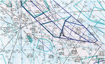
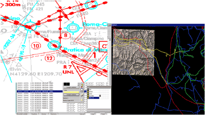
The Aeronautical Geotopographic Information Centre (CIGA) is the State Cartographic Authority, based on Law no. 68 of 1960, responsible for the production of Aeronautical Cartography which, in addition to aeronautical information, also shows obstacles to air navigation.
 
In the event that a company or an individual wishes to assess the feasibility of a structure that may represent an obstacle to air navigation, outside areas of absolute prohibition on construction and in relation to military airports as defined in Ministerial Decree of Defence 19 December 2012 no. 258, it is mandatory to also obtain the “military clearance”.
 
For the construction of works, the Aeronautica Militare issues the technical-operational clearance for the safety of air navigation. The authority for this concession, depending on the territory in which the work falls, is exclusively delegated to the following Territorial and Heritage Departments, which will constitute the exclusive ’point of entry/exit“ for requesting and issuing the relevant opinions:
 
AERONAUTICA MILITARE COMMAND 1ST AIR REGION
DISTRIBUTION TERRITORY AND HERITAGE
E. NOVELLI SQUARE 1, 20129, MILAN
Tel.: 02 73906074 
Fax: 02 7390 3409
for installations to be carried out in the Regions of Valle d'Aosta, Piedmont, Lombardy, Liguria, Trentino-Alto Adige, Friuli-Venezia Giulia, Veneto, Emilia-Romagna, Tuscany, Umbria and The Marches.
 
AERONAUTICA MILITARE COMMAND SCHOOLS OF THE AM / 3RD AIR REGION
DISTRIBUTION TERRITORY AND HERITAGE
LUNGOMARE NAZARIO SAURO 39, 70121, BARI
Tel.: 080 5418422
for installations to be carried out in the Regions of Lazio, Abruzzo, Molise, Campania, Puglia, Basilicata, Calabria, Sicily and Sardinia.
This Centre does not participate in Service Conferences nor contribute to the military clearance process, but is interested solely and exclusively in receiving communication from the construction companies, upon the granting of clearances by all relevant authorities and, at least 30 days before the start of works, all characteristics, technical data, colour or light signalling equipment and further information contained in the’Annex II
or in the’Annex III:
linear obstacles, in one of the following methods, also indicating the contact details for any communications:
 
The Aeronautical Geotopographic Information Centre shall collect data relating to obstacles, as notified by the constructing companies/firms, in a database, update the aeronautical information publications necessary for the correct and safe conduct of flight operations, and represent them, where necessary, on the cartography under its responsibility.
 
The CIGA points of contact for flight obstacle practices are:
  • Geotopographical Processing Service
  • Topographical Survey Section
  • Obstacle Core
 Tel.: 06/91293741 – 06/91293725